Saltar para o inicio
Loading/A Carregar
  • Botão Hmais Utility Menu
  • Botão Loja Utility Menu
  • Botão ANAVNET Utility Menu
  • Botão Avisos Utility Menu
  • Botão Arquivo Utility Menu
English Português
Logotipo Instituto Hidrográfico
  • Logotipo Instituto Hidrográfico
  • HI
    • News
    • The Hydrographic Institute
    • The Director-General
    • Institutional Documents
    • Magazines/Publications
    • Quality
    • Recruitment
    • Equality Plan
    • Complaint Channel
  • Products and Services
    • Nautical Cartography
    • Safety of Navigation
    • Oceanographic forecast
    • Services
  • Resources
    • Ships and vessels
    • Unmanned vehicles
    • Laboratories
    • Equipment
  • Activity
    • Programs
    • Projects
    • STANDARD S-100
    • Data Infrastructures
    • IH SensorTech
    • Hydrographic Brigade
    • CGEOMETOC
    • Hydrographic Cartography Regulation
    • Events
  • Data
    • Access to data
    • Data transfer
    • Documentation
  • Infoteca
  • Links
    • NATO MGEOMETOC-COE
    • Public procurement

Techinfo

Installations Special missions 60 Years of the Instituto Hidrográfico

60 Years of the Instituto Hidrográfico

Embarcação «Mina»

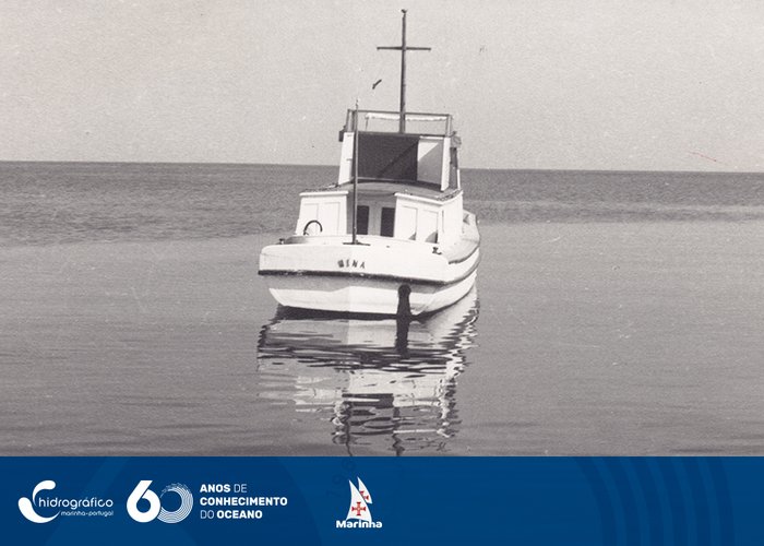
The ‘Mina’ vessel that carried out the Hydrographic Survey of Lake Niassa. The work began in 1955.

Missão Hidrográfica de Angola

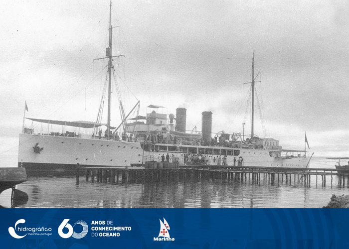
Angola Hydrographic Mission - Report 1940/41

  • Anterior
  • 1
  • 2
  • 3
  • 4

Informations

  • Legal Notice
  • Cookies
  • Accessibility
  • Site Map
  • Site Map

Contacts

Instituto Hidrográfico
Rua das Trinas, nº 49
1249-093 Lisboa
Tel: +351 210 943 000 Access the contact forms
Logo República Portuguesa Logo Marinha Portuguesa Logotipo Instituto Hidrográfico
APCER ISO 9001 Quality System
Logotipo com transparências youtube do IH Facebook do IH Linkedin do IH

© Instituto Hidrográfico @ 2026
  • HI
    • News
    • The Hydrographic Institute
    • The Director-General
    • Institutional Documents
    • Magazines/Publications
    • Quality
    • Recruitment
    • Equality Plan
    • Complaint Channel
  • Products and Services
    • Nautical Cartography
    • Safety of Navigation
    • Oceanographic forecast
    • Services
  • Resources
    • Ships and vessels
    • Unmanned vehicles
    • Laboratories
    • Equipment
  • Activity
    • Programs
    • Projects
    • STANDARD S-100
    • Data Infrastructures
    • IH SensorTech
    • Hydrographic Brigade
    • CGEOMETOC
    • Hydrographic Cartography Regulation
    • Events
  • Data
    • Access to data
    • Data transfer
    • Documentation
  • Infoteca
  • Links
    • NATO MGEOMETOC-COE
    • Public procurement
Site Map
  • HI
    • News
    • The Hydrographic Institute
    • The Director-General
    • Institutional Documents
    • Magazines/Publications
    • Quality
    • Recruitment
    • Equality Plan
    • Complaint Channel
  • Products and Services
    • Nautical Cartography
    • Safety of Navigation
    • Oceanographic forecast
    • Services
  • Resources
    • Ships and vessels
    • Unmanned vehicles
    • Laboratories
    • Equipment
  • Activity
    • Programs
    • Projects
    • STANDARD S-100
    • Data Infrastructures
    • IH SensorTech
    • Hydrographic Brigade
    • CGEOMETOC
    • Hydrographic Cartography Regulation
    • Events
  • Data
    • Access to data
    • Data transfer
    • Documentation
  • Infoteca
  • Links
    • NATO MGEOMETOC-COE
    • Public procurement