

Standard S-100
The Next Generation of Electronic Navigation Charts (ENCs)
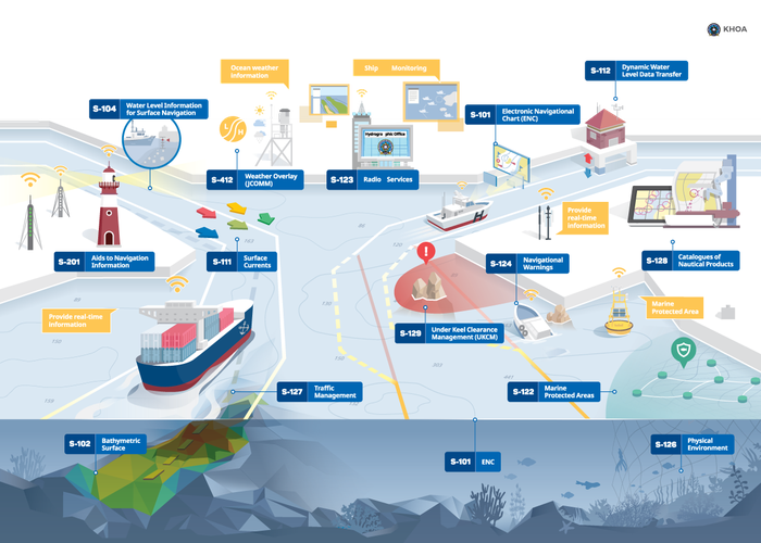
The S-100 “Universal Hydrographic Data Model” is a new standard developed by the International Hydrographic Organization (IHO), establishing the theoretical framework for a comprehensive and integrated hydrographic data model. It has been designed to address a broad spectrum of user needs and applications. The S-100 framework encompasses a suite of interoperable and mutually compatible products and services aligned with the latest generation of electronic navigational charts. Its implementation aims to enhance the safety and efficiency of navigation through real-time integration of reliable models, data, and observations; to support maritime and port management; to facilitate technical and scientific research; and to foster the sustainability and preservation of the marine environment.
The S-101, S-102, S-104, S-111, and S-124 standards are particularly noteworthy.
What is S-101?
S-101 is the new standard for the production and distribution of Electronic Navigational Charts (ENCs), aligned with the new hydrographic data structure and model S-100, developed by the International Hydrographic Organization (IHO).
S-101 will be the product specification that defines how hydrographic offices will produce and distribute ENCs for display in ECDIS, replacing the current standard, S-57. It will be fully interoperable with a wide range of other hydrographic and marine datasets as part of the broader ecosystem defined under S-100.
How do S-101 ENCs differ from the current S-57 ENCs?
S-57 was formally adopted in 1992 and implemented by the IHO to enable the exchange of hydrographic information between hydrographic offices, ECDIS manufacturers, mariners, and other users. However, it has remained static since edition 3.1 (November 2000), meaning it cannot be updated to keep pace with the evolution of navigation towards the “e-navigation” concept presented and regulated by the IMO (International Maritime Organization).
S-101 is not a radical reformulation compared to S-57, but it reflects changes in the data structure and model to accommodate this new concept.
S-101 will serve as the baseline layer for other interoperable datasets within the S-100 framework and will be much more flexible to accommodate a wide range of products and services, not only related to navigation but also to the marine environment. While many aspects of ENCs will remain the same, there will be some important differences in the representation of navigation data, all developed with the users in mind.
S-101 ENCs will intentionally maintain the same appearance and visualization in ECDIS as the current S-57 ENCs, as navigators are accustomed to, in order to preserve familiarity in their use, promote situational awareness, and continue to ensure the safety of navigation.
When will mariners be able to start using S-101 ENCs?
The new IMO resolution "Performance Standards for ECDIS", adopted in November 2022, will allow shipping companies to upgrade ECDIS for the new s-100 products from 2026. The new S-100 ECDIS will also support the display of S-57 data alongside the new S-100 products (Dual Fuel Period).
From 2029, all new ECDIS installed onboard must be compatible with and comply with the IMO’s S-100 Performance Standard.
The Instituto Hidrográfico is aligned with the international planning of the IHO and IMO and intends to begin phased operational production of S-101 ENCs from 2026.
S-10 Data Model
13 
2025-09-16