

Cartography
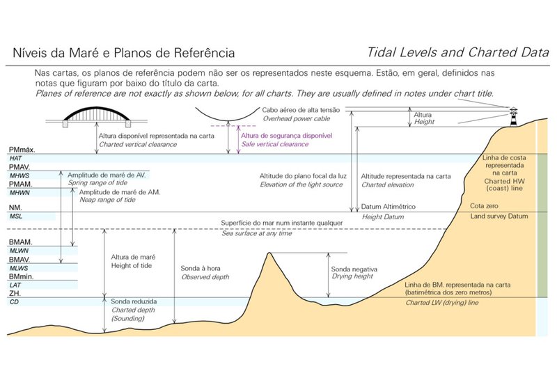
The Zero Hidrográfico (ZH) is the chart datum used in Portugal.
ZH is located below the level of the Lowest Astronomical Tide (LAT). ZH is the vertical reference for the soundings and depth contours represented in the nautical charts, as well as the tide height forecasts that are published in the Tide Tables of the Instituto Hidrográfico.
For navigation safety purposes, hydrographic data must be reduced to ZH Portugal depth, in depths down to 200 m. Depths are represented in metres (m) by positive values below the ZH, and negative values above the ZH.
The relationship between ZH Portugal (depth) and vertical datum (height) depends on location and LAT. For each geographic extension, the value of the correspondence between the ZH Portugal (depth) and the respective Vertical CRS (height) can be consulted HERE.
Similarly, for Lusophone African countries, there are several ZH's established in relation to the tide stations implemented.
For more information see the “Tide Tables” published annually by the Hydrographic Institute and made available to download at Loja do Navegante
In August 2023, the IOPG Geomatics Committee assigned a code European Petroleum Survey Group (EPSG) to the Portuguese ZH, while Vertical Coordinate Reference System (Vertical CRS).
The use of the code EPSG: 10349 - ZH Portugal Depth (Vertical CRS) is recommended by the Instituto Hidrográfico, for all hydrographic data that are related to ZH, in mainland Portugal and in the Azores and Madeira archipelagos.
391 
2024-05-27