

Top Hydrographic Survey on Madeira and Porto Santo Islands
A team of four members of the Hydrographic Brigade (BH) conducted top-hydrographic surveys (LTH) on the islands of Porto Santo and Madeira, from 18 March to 9 April 2022, with the aim of obtaining updated top-hydrographic information for cartographic update purposes.
The BH team embarked on March 18 aboard the NRP D. Carlos I, along with the diving vessel Simmerhão, equipped with a high-resolution multi-beam system. Equipment was also mobilized for topography, geometric leveling and three campaign tidegraphs.
On March 21, the team with the Srughão landed in the port of Porto Santo to carry out the first survey. This LTH lasted one-and-a-half days where the port of Porto Santo was polled, a tidal wave installation, Geometric Leveling (NG), GNSS coordinations of 6 Support Points (PA) and cartographic topography.
On May 22nd the team and Scuba Digger re-embarked in NRP D. Carlos I headed for the island of Madeira where they landed the next day, along with the boat and all the material.
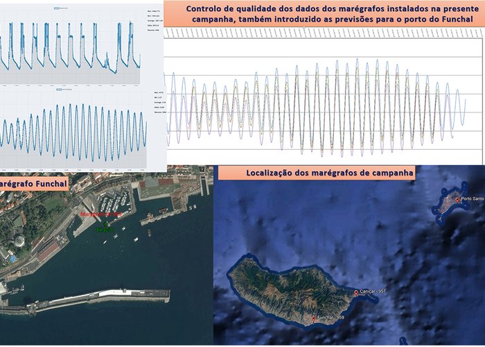
During the two weeks of stay on the island of Madeira, 3 hydrographic surveys were carried out: port of Funchal, port of Caniçal and nature reserve of Garajau. Nine points of support were also coordinated, a geometric leveling was carried out in three locations and campaign tide graphs were installed – one in the port of Funchal and the other in the port of Caniçal.
In total, three campaign tidegraphs were monitored throughout the mission period. The tidal wave of Funchal was maintained, belonging to the national network of the Hydrographic Institute.
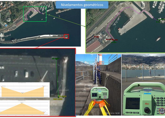
This mission carried out the recovery of PA with NG in Porto Santo, Caniçal and Funchal, restoring a robust local network of PA with NG having their concern prevail in time.
The establishment of a robust network of support points was predominant for the study of a global geoid model EGM 2008 1’ to verify its applicability to the various ports. This study was conclusive, and the model was applied to hydrographic data with the introduction of a different vertical adjustment for each port in order to reduce ellipsoidal altitude to the orthometric altitude obtained by geometric leveling.
This mission highlights the update of river information in ports. This information is of utmost importance for the safety and maintenance of confidence of maritime operators, knowing that the port of Funchal is one of the main ports of Portugal, being at present the national port with the greatest movement of tourists and the 13th at European level, and the port of Caniçal, a sensitive place for the supply of Madeira Island, where port vessels, ships with fuel supplies and fishing vessels dock.
A hydrographic survey was also carried out in the partial natural reserve of Garajau, thus contributing to the sustained development of Madeira in the protection of the marine environment and knowledge of its natural wealth, enhancing the increased knowledge of the seabed with baptometric models of great resolution that allow planning and mapping in the control of the species that inhabit the site.

Top Hydrographic Survey on Madeira and Porto Santo Islands

Top Hydrographic Survey on Madeira and Porto Santo Islands
Top Hydrographic Survey on Madeira and Porto Santo Islands
Top Hydrographic Survey on Madeira and Porto Santo Islands
153 