

Added 45,000 more Km2 to the Portuguese Sea Mapping project
The NRP D. Carlos I it docked yesterday, August 19, in Ponta Delgada, meeting on mission in the Azores Archipelago since July 15 with the objectives of conducting hydrographic surveys (LH) in the framework of the project Mapping of the Portuguese Sea, strengthen the Permanent Naval Device in the Maritime Zone of the Azores (ZMA), cooperate in the technical and scientific scope with the Regional Government of the Azores and the University of the Azores, collaborate with the Mission Structure for the Extension of the Continental Platform (EMEPC) as well as with the Interdisciplinary Center for Marine and Environmental Research (CIIMAR) of the University of Porto.
The Navy is aware that the detailed knowledge of the seabed ensures sustainable development and the protection of the marine environment, started an ambitious project in 2017, following a strategic option of the Navy, of Mapping the Portuguese Sea, so that the country can effectively know and take advantage of these vast maritime spaces. Consequently, knowledge of the ocean, in general, and of the seabed and the marine subsoil, in particular, appears to be a task of unparalleled strategic importance, and will certainly be an invaluable legacy for future generations.
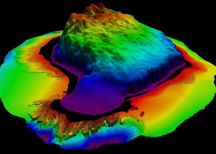
In this campaign LH Azores 2019 and in the framework of the Mapping of the Portuguese Sea in the Azores archipelago, two distinct phases were carried out with the duration of 28 days of operation at sea: the first, in the hydrographic survey with multi-beam sonar of the underwater hills (which are rich ecosystems of particular relevance) to the south of the Flores Islands framed in cooperation with the University of the Azores. Six underwater mounds of medium and large (high resolution) sonars were probed for a total of 3 560 Km2; the second phase, also consisting of a hydrographic survey with multi-beam sonar, the Southwest of Flores Island, in a remote zone beyond the Azores EEZ, which stems from collaboration with the Mission Structure for the Extension of the Continental Platform. Under the Portuguese Sea Mapping the ship scanned a total of 41,800 Km2.
In the Western and Central groups were two Hydrographic Brigades that carried out the survey of port and coastal areas in the São Jorge, Flores and Corvo Islands for cartographic update in a collaborative project with the Regional Government of the Azores.
As a result, the nautical charter of the Port of the House (Corvo) was elaborated and obtained data of excellent resolution of the ports of Calheta and Velas (São Jorge), Lajes (Flores), as well as the coastal area of Ponta dos Rosais (São Jorge) and the entire perimeter around the Island of the Corvo. In the western group, 44.8 Km2 were probed and in the central group 22 Km2 having traveled 750 km and 465 km of spin respectively. These teams also carried out topography work on new port infrastructures and several Navy buildings.
Thus, they were added to the Portuguese Sea Mapping Project 45.475 Km2 of polling.
It should be stressed that the Navy, with the presence of NRP D. Carlos I, reinforced the dynamic naval device of the Azores Region, increasing the search and rescue capabilities (SAR), maritime surveillance and patrolling, supporting civil protection agencies, collaborating with the University of the Azores in conducting scientific campaigns and cooperation with other departments of the State with powers at sea, aware of the relevant geostrategic position that the Azores Archipelago represents.
O NRP D. Carlos I has a garrison of 38 military personnel, embarks two teams of the Hydrographic Brigade consisting of eight elements and two observers of cetaceans of the CIIMAR, having predicted their return to Lisbon on 27 August.

Added 45,000 more Km2 to the Portuguese Sea Mapping project
Added 45,000 more Km2 to the Portuguese Sea Mapping project

Added 45,000 more Km2 to the Portuguese Sea Mapping project

Added 45,000 more Km2 to the Portuguese Sea Mapping project

Added 45,000 more Km2 to the Portuguese Sea Mapping project

Added 45,000 more Km2 to the Portuguese Sea Mapping project
172 
2019-08-20