

Services
MARINE GEOLOGY DIVISION
The need for understanding the geological nature of the seabed and its dynamics has driven the development of expertise for conducting geophysical surveys and sediment sampling, as well as the subsequent samples and data processing. The interpretation of results addresses a wide range of requests, particularly those related to the characterization and monitoring of environmental evolution (sedimentary aspect), support for spatial planning, and the development of economic activities (such as the installation of structures on the seabed and monitoring the evolution of the seabed where these are located), assessment of natural resources, and support for dredging operations, among others. Regardless of the objective and purpose, all acquired data and information, once approved by the funding entities, are reused to promote scientific knowledge and the defense of national territory.
A direct application of the existing skills, particularly those related to the detection and localization of structures in the sedimentary seabed, consists of the support provided to the Navy and civil society in emergency situations. Notable examples include the detection and identification of wrecked ships (the most known accident being the vessel “Bolama,” missing since 1991), crashed aircraft in the sea (such as the Cessna in Sesimbra or the aircraft in Trafaria), and the detection of submerged vehicles in aquatic environments (Entre-os-Rios, Borba quarries, etc.).
In response to the requests and needs of stakeholders, the division is prepared to conduct surveysthat enable the acquisition of geological data and sedimentary samples, that will be analysed in the framework of multidisciplinary studies, encompassing the following three areas:
- Sedimentary cartography and geomorphological mapping of the seabed;
- Description of the sedimentary layer structure (thickness, seismic stratigraphy, and mapping);
- High-resolution mapping and detection of objects or structures.
1. SEDIMENTARY CARTOGRAPHY AND SEABED MAPPING
Programs such as the Sedimentary Cartography of the Continental Shelf (formerly SEPLAT and currently SEDMAR) have been developed since the early years of the IH, producing complementary information to enhance hydrographic cartography products and providing supporting data for decision-making in any project or study conducted in the submerged national territory.
Since its establishment, the IH has always had the capability to collect, analyze, and classify representative seabed samples, aiming to represent the distribution of sedimentary deposits on the seabed of coastal zones, particularly in areas of the continental and insular margins that are of greater interest for the development of economic, scientific, and environmental protection initiatives.
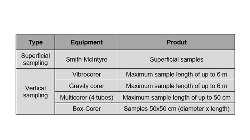
Various sediment samplers are operated by specialized IH technicians aboard oceanographic vessels. With successive improvements and advances, sampling techniques have evolved over time. The initial superficial samplers (Van Veen and Shipeck) have been replaced by the Smith-McIntyre samplers, which are highly efficient up to depths of 1000 m and ensure the collection of sedimentary samples from the upper 10-15 cm of the seabed.
For sampling in very shallow areas, the manually operated Petit Ponar sampler is used.
2. DESCRIPTION OF THE SEDIMENTARY LAYER STRUCTURE (THICKNESS, STRATIGRAPHY AND MAPPING)
For the three-dimensional characterization of the marine subsurface, particularly the determination of the depth of the rocky substrate, the internal structure of superficial sedimentary layers, and their spatial variability, geophysical surveys are conducted using single-channel light seismic reflection systems. Covering the entire continental shelf up to approximately 400 meters, the existing systems have variable penetration capabilities (from a few meters to several hundred meters) and good resolutions (on average between 10 and 50 cm), depending on the type of material and the frequency of the emitted signal.
Currently, the IH operates the following seismic reflection systems:
- Boomer AA301 from Applied Acoustic.
- TOPAS PS120 from Kongsberg.
On the basis of the preliminary interpretation of the registers, thematic maps are produced with the intended information, highlighting:
- map of rocky outcrops and location of the rocky substrate;
- maps of thicknesses of the various seismic units;
- mapping geological structures (failures,...).
Using the information obtained from geophysical surveys, vertical sedimentary sampling is planned, employing vertical samplers, that are selected according to the sampling objectives, the analyses to be performed, and the geological characteristics of the study area. With the capability to collect samples of unconsolidated sediments at different depths and lengths, the IH has the following sampling systems:
The collected samples are transported to the Sedimentology Laboratory, where they are processed, described, subsampled, and analyzed to confirm the information obtained through geophysical methods and to characterize the sedimentological and geotechnical properties of the marine soil and subsurface. Access the sedimentological tests conducted by the IH.
All analyses performed in the Sedimentology Laboratory are documented in Individual Test Reports. The obtained lab information can be interpreted, leading to the creation of thematic maps representing the spatial variability of the analyzed parameters.
Among the most demanded products, the IH provides processed and interpreted seismic profiles using seismic-stratigraphic criteria; maps of the thicknesses of various seismic units; location of the rocky substrate or reflector surfaces; brittle deformation structures (faults); individual vertical sample records; test reports; and thematic mapping representing the sedimentary nature of the seabed.
3. HIGH-RESOLUTION MAPPING AND DETECTION OF OBJECTS OR STRUCTURES
Any maritime space occupation project requires detailed knowledge, with high resolution and accuracy, of the surface geological characteristics and the presence of potential structures or objects that may increase the risk to structures.
Capable of producing seabed maps with decimetric resolution, the IH operates side-scan sonar systems. Data acquisition campaigns with these systems are designed to obtain an acoustic mosaic of the area of interest (with full seabed coverage), distinguishing areas with different acoustic backscatter and roughness (parameters associated with the geological nature, outcropping structures, and active sedimentary dynamics processes).
The side-scan sonar systems operated by the IH, from the KLEIN brand, are as follows:
- KLEIN 3900
- KLEIN 5000v2
- KLEIN MA-X VIEW 600
To complement the information obtained from side-scan sonar, magnetometers are used to quantify magnetic anomalies caused by the presence of specific rock types, objects, or metallic structures located on the surface or partially buried in the first few meters of the sedimentary layer. Currently, the IH has magnetometers from Marine Magnetics, specifically a system with two SeaSpy2 magnetometers, which can be operated in a gradiometer configuration, with sensors offering a sensitivity better than 0.01 nT.
Among the most sought-after products, the following are listed: acoustic mosaic of the seabed; high-resolution mapping of the sediment/rock bottom; magnetic anomaly map; detection and classification of objects (table with position, characterization, dimensions, and shape).
Regarding the detection and localization of structures and objects, the IH also has a remotely operated vehicle, ROV TORTUGA (from SubSea Tech), capable of diving up to 250 meters deep. This ROV is used to confirm the classification of objects found on the seabed that have been detected using side-scan sonar and magnetometer systems.
Products: Videos of underwater inspections (e.g., direct observation of the seabed and underwater structures) under challenging operational conditions (e.g., long-range inspections, low-visibility situations, or extended dive durations).
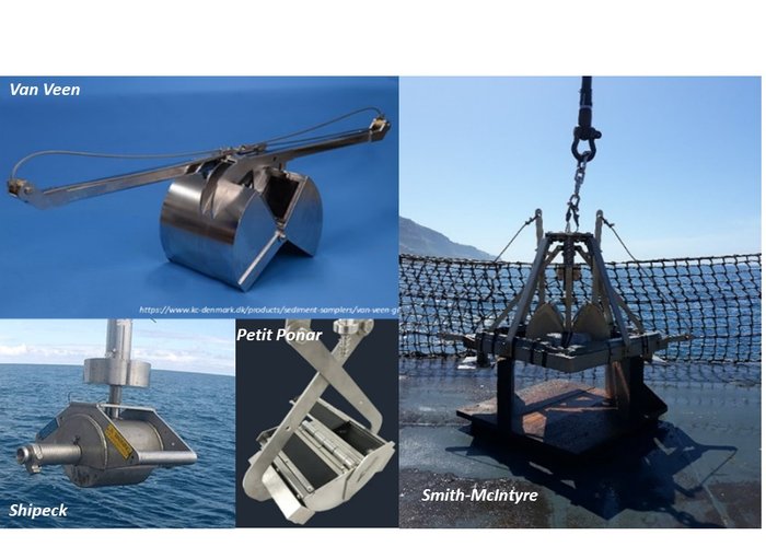
Superficial sediment samplers
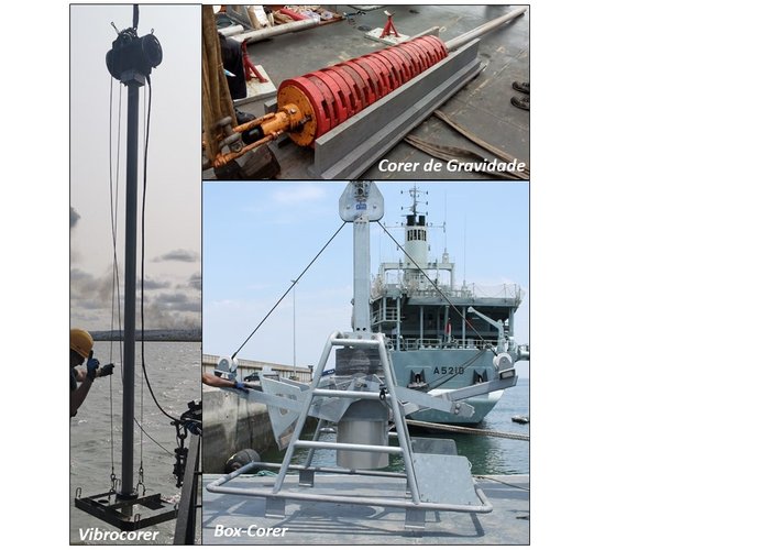
Vertical sediment samplers
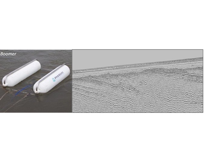
Seismic reflection systems - BOOMER AA301
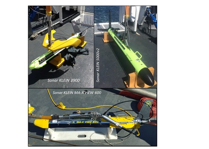
Side-scan sonar systems
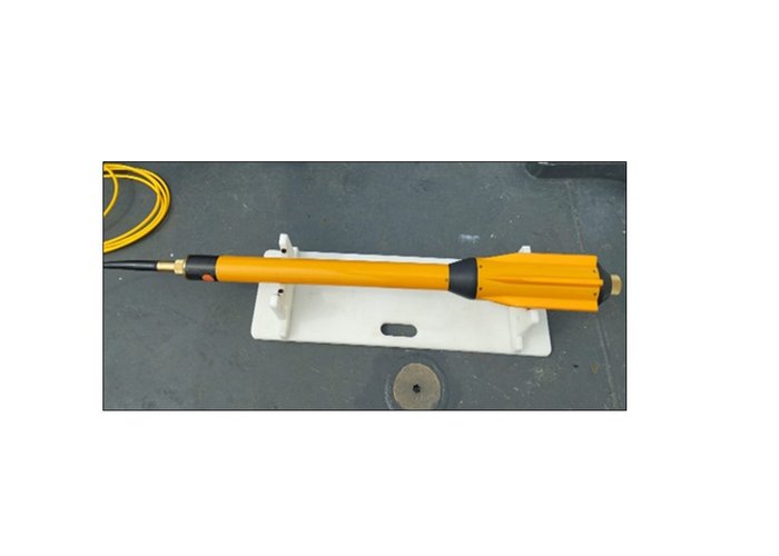
SeaSpy2 magnetometer
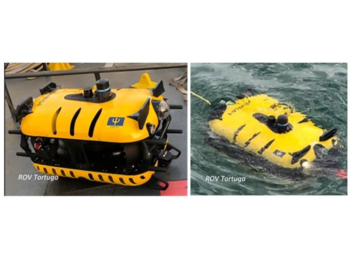
Remotely operated vehicle - ROV TORTUGA
37 
2025-09-17