

SEAMAP 2030
Portuguese Sea Mapping
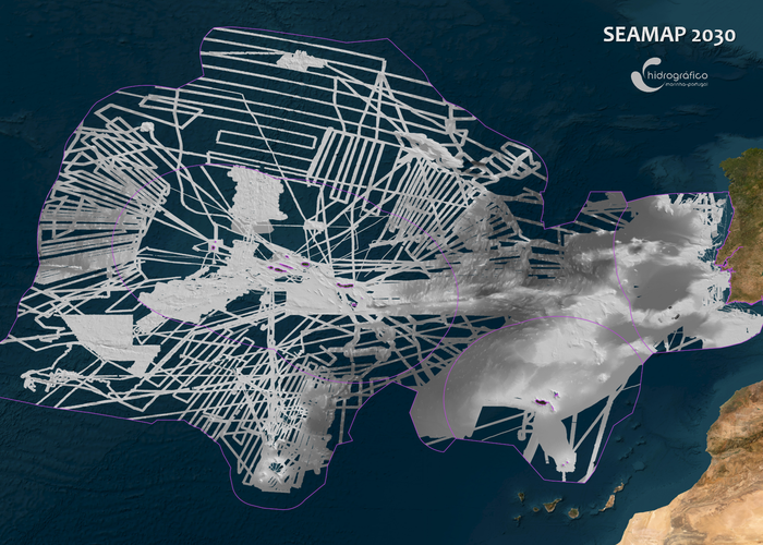
The program SEAMAP 2030, of the Instituto Hidrográfico (IH), aims to contribute to the global knowledge of the seabed morphology, completing the mapping of high resolution of national maritime spaces by 2030, thus contributing to the conservation and sustainable use of the sea, supporting research and promoting development.
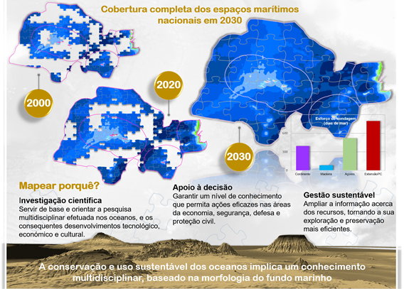
In 2004, Portugal began conducting high-resolution hydrographic surveys of the ocean floor using multibeam echo-sounders, which are a key requirement in supporting the proposal for the extension of the continental shelf beyond 200 nautical miles, submitted by Portugal to the United Nations. These hydrographic surveys were carried out within the scope of the mission of the Task Group for the Extension of the Continental Shelf (https://www.emepc.pt/), aboard the Portuguese Navy’s oceanographic vessels NRP D. Carlos I and NRP Almirante Gago Coutinho. The IH was responsible for the acquisition and processing of the hydrographic data, as well as for ensuring their quality control.
With the initial goal of increasing bathymetric coverage in the coastal areas of the Azores and Madeira archipelagos, the IH created, in 2017, the “Mapeamento do Mar Português” program. This initiative soon evolved into a broader vision by joining the SEABED 2030 program (https://seabed2030.org/), and was subsequently renamed SEAMAP 2030.
More recently, the IH has been requesting bathymetric data from other national and international institutions, including data collected during scientific cruises conducted in Portuguese waters. Once validated, these data are also integrated into SEAMAP 2030, thereby contributing to the enhancement of national bathymetric coverage.
Data download: https://geomar. hydrographic. pt/
See the current state of SEAMAP 2030.
Portuguese Sea Mapping
Why Mapping the Portuguese Sea?
392 
2025-08-12